
Geo pressure signify potential hydrocarbon reserve in offshore Bangladesh
Geo pressure signify potential hydrocarbon reserve
Petroleum is leading energy source and will dominant as prime
source for next 2-3 decades. After
2050 petroleum may loss it’s top position as raw energy source and may decline consumption of petroleum all
over the world. Consequently petroleum will no loger be the primary object
of energy generation and will
reduce the worldwide hydrocarbon exploration activities. Only for late decision
of offshore exploration it may
remain unexplore vast offshore area of Bangladesh, whilst the offshore drlling technology will be insufficient and costly in
future.
Geologically Bangladesh is located at mouth of active Bengal
delta and in the subduction zone of Burmese plate & Indian plate.
Hydrocarbon reserve in this deltaic region have great effect of plate tectonic
movement, very rapid & juvenile sedimentation process and undeformed
compaction of sediment. For hydrocarbon exploration drilling is ultimate method
for extraction of oil & gas from reservior and it is most important to analyse subsurface formation, related
positive or negative geopressure anomalies and ultimate status of petroleum
reservoir.
It is now possible to view the petroleum province within an
overall geodynamic picture resulting from an integration of structural
deformations, sedimentary changes, heat flow, fluid transfer or migration etc.
In fact all are intimately linked and a variation in any one parameter acts on
all others, constitute the petroleum system.
Geopressure and its superficial effects has long played an
important role in petroleum exploration. There is always an element of risk with
any drlling operation but the pressence of abnormally pressured sequences can
significantly increase these difficulties, successful drilling requires the use
of every means of detection at our disposal.
Hydrocarbon exploration and petroleum reservoir characteristics in bengal delta
is much more affected by geopressure anomalies and before drilling need analysis
the regional geology of prospect area.
Hydrocarbon reservoir does not depend on artifical man made
boundary of country but depends on regional geological history. Hence
discussing hydrocarbon reservior status in coastal & offshore part of
Bangladesh considering subsurface geopressue of regional geology. Bengal basin
is part of Myanmar, Bangladesh & India and basinal part of Bangladesh is
realtively at down slope of Myanmar and in middle of Bengal basin. Sedimentary
thickness of Bengal basin is almost 20-22km thick and in the form of arch
& synclinal basin design represent
more sedimentary thickness.
Resulting force of plate movement has great effect on sedimentary bodies, twist the sedimentary body into different sub structure like fold, fault, fracture etc. Sedimentary body of southern part of Bengal basin is divided into two types of structural view by thrust fault, i.e. uplifted south eastern fold belt and north western plain land with southern coastal & offshore part. South eastern foldbelt is highly compressed and pressurized rock body. High compression makes fault and fracture inside formation thus affect the hydrocarbon reservoir, seal and migration. South eastern uplifted foldbelt & adjoining area is quite unpredictable for high intensity of geopressure anomalies. Hydrocarbon of this area especially natural gas could leach to nearest closure or even can be out through surface feature linked with internal fracture or fault of rock sequences.
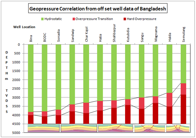
From
limited scope a study of regional geo pressure is made from nearby offset well
data of coastal & shallow sea of Bangladesh. Above figure represents actual
status of geo pressure and hydrocarbon reservoir in this area. In Bangladesh
hydrocarbon reservoir is mainly in formation of Mio-Pliocene age above identified
over pressure zone. It shows Semutang, Halda & Magnama is highly compressed
& pressurized and subsurface is greatly affected by fault & fracture
and geo pressure is upward with depth. The Indo-Burman range is located to the east of Magnama and passage by Semutang & Halda marks the nearby zone of plate collision. By the
Late Eocene time the direction of Indian plate convergence changed from north
to northeast with increasing collision with Southeast Asia. Deformation
is strongest as plate move north eastwards towards the Indo-Burman range. This
is evidenced by the increase in shallowness of over pressure zone.
South
eastern fold belt & adjoining coastal
area will not be good hydrocarbon reservoir as commencing high convergence, high angle inclination & less
extension of sedimentary sequences, affected factor of plate tectonics and very
close to subduction zone. Drilling in this area might be less prospective and
hazardous. Sangu, Kutubdia, Sandwip, Shahbazpur, Hatia, Sonadia and Char Kajol
is comparatively at down slope of coastal area, gently sloping down to south & southwest direction towards
offshore and is relatively far
away from the Indo-Burman range and less affected by plate tectonics. Most
structures are hydrocarbon charged and some of the drilled wells in this area are in production track. Nearby
location like CharJabbar, Manpura, Bhola and adjoining structures are highly
prospective for hydrocarbon considering regional geo pressure trend and
geological criteria. Over pressure of BODC and Bina well location is relatively
deeper and almost has no effect
of plate tectonics. South western Bengal basin
of Bangladesh part can be affected by Barishal-Chandpur gravity high and hydrocarbon reservoir in this area can also
be affected. Though don’t have available
data of this region but assume offshore will be hydrocarbon rich area.
Comparatively
geo pressure trend is gently sloping down from south eastern coastal region to deep
offshore of Bengal basin in the direction of south & southwest. Thick sedimentary
sequence with overlying water body of deep offshore area is less affected by
plate tectonics and has wide extension of rock formation can be indicative of
good hydrocarbon reservoir. Sedimentary rock of Bengal basin is organic rich,
hydrocarbon maturation time & migration is also favorable for hydrocarbon
generation. As less effect of plate tectonics in sedimentary rock sequence of
deep offshore area may have possibilities of oil discovery in Pleistocene
formation at shallow depth and Mio-Pliocene formation above over pressure will be highly prospective for
hydrocarbon.
For
hydrocarbon exploration seismic data acquisition is primary procedure for defining
sedimentary structure of hydrocarbon reservoir. In this regard qualitative data
acquisition is most important for proper analysis, facts that work in offshore are
quite expensive and hazardous. In view of qualitative data acquisition Multi
client seismic survey will not be authentic rather have possibility of data manipulation
considering the liability of risky
offshore work. Manipulated data will never represent the real subsurface feature
other than it may misguide the
expensive exploration work. Better option is search for IOC and proceeds
for offshore bidding & move on details negotiation for signing PSC
(Production Sharing Contract). Seismic data acquisition in offshore under
PSC will be more qualitative as cost recovery is related with hydrocarbon discovery of respective offshore block.


No comments